50 State Quest: #46 Alaska
As I close in on my 50 states, which I should reach by next summer, I am already thinking about what comes next. That, however, is a post for another time. Many of my recent states have involved short visits, many just a meal or an overnight, but I took a week’s vacation in Alaska. This made my visit to my 46th state very different. And it makes this blog post different because it needs to cover lots of territory, just like our nation’s largest state.
Let’s start with some statistics from the week before I get into the detail:
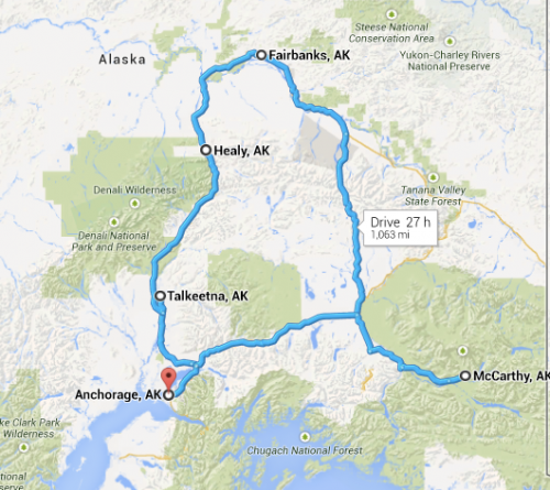
I drove 1133 miles.
Fitbit, my activity tracker, tracked 150,000 steps.
I took nearly 1,000 pictures with three different cameras.
If you don’t feel like reading all the details and want to go straight to the pictures, I have shared them on my Flickr account. And don’t worry, they are edited, so there are just under 200.
And one more thing before I get started. I was so active on this trip that I was not able to write most of this as it was happening. This means some of my thoughts and impressions of the week may have already faded. This is not true of my long drive down the Richardson Highway because I was recording my thoughts in a series of audio notes. I was only made fun of once for this, but I think those thoughts may come in handy along the way.
Day 1
It was a long trip to Alaska and my plane arrived at about 2 in the morning. Even though I had slept some on the plane, due to the four hour time difference, it felt like 6am to me. By the time I got my luggage, a taxi and made it to where I was staying, it was almost 3 in the morning Alaska time. I knew I needed at least a little bit of sleep before I began my day, so I got in bed, read a little bit to wind down and fell asleep. I stayed in an apartment through AirBnB downtown. I had a private entrance to this upstairs space and never saw my host. It had a full kitchen that I never used. It even had an accessible Netflix-streaming account that I didn’t use, but I did flip through the suggestions to see what Netflix recommends to a random set of people with different tastes. I was surprised how different it was from my recommendations.
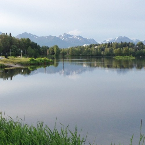
This sleep was more like a long nap, as I woke up 2 hours later, and my body was not sure what time it was. A run along the Tony Knowles Coastal Trail seem like the best way to get this day going. I also got my first view of the Chugach Mountains.
After my run I went to the Snow City Cafe for breakfast. It is the place for breakfast in Anchorage. It opens at 7am, and by 7:10 there is a 20-30 minute wait. I didn’t know this yet, so when I arrived at 7:30 I had a bit of a wait. It was worth it though. I had two small eggs benedicts. It was a sampler of their two popular choices. One had a salmon cake and the other had a crab cake. I added a side order of reindeer sausage to this Alaskan breakfast. And I was stuffed.
I started my touristy part of the day with a ride on the City Trolley. While I expected this to give me a good overview of the city, it went outside the city to places like Lake Hood, the world’s largest floatplane airport, and Earthquake Park, where you can see that the land dropped about 15 feet due to a 9.2 magnitude earthquake in 1964. I also saw my first moose on this trolley ride. The moose population is so great that there is one moose per 2 square miles of Anchorage.
The trolley brought me back to downtown and I walked to the Anchorage Museum. I learned about about local history and culture in this combination history, art, science and kids museum. I started by looking at the artwork, and I started to understand how Mt McKinley, North America’s highest peak doesn’t just loom on the landscape, but it looms large in people’s minds and imagination. I would see that in person in a couple days. I took a guided tour that described the history and the native people of Alaska. This prepared me for my next stop, the Alaska Native Heritage Center. I took a free shuttle to Native Heritage Center, as it is about 15 miles from downtown.
According to the Native Heritage Center, “Alaska’s native people are divided into 11 distinct cultures, speaking 11 different languages and 22 different dialects.” And none of these cultures are called Eskimo. The Center features a large gathering space with a stage, where the native people share their culture. I saw athletic competitions, song and dance presentations and storytelling. This was a better way to understand the native that looking at static museum displays.
The outside part of the center featured separate village sites, each representing a different culture. These spaces ring a lake, creating a beautiful environment to spend the afternoon. There were native people from that culture in each of the sites, sharing stories about their heritage and their people. Some of these guides were awkward teenagers who could have benefitted from additional training.
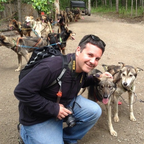
I also got to experience a dog team ride. John Baker has set up camp at the Center, offering a glimpse into the world of mushing. He is a veteran dog musher, took first place in the 2011 Iditarod race and broke the record for fastest finish by four hours. I rode on a wheeled cart as 18 Alaskan Huskies pulled us around a wooded trail. And I got to hold a 4-week old puppy.
I had King Salmon for dinner and an IPA at the Glacier Brewhouse. This is one of the busiest restaurants in the summertime, and it is impossible to get a last minute reservation. But as a single traveler, I sat at the bar and was able to get a beer and order from the dinner menu.
Day 2
During the course of my first day, I did a lot of walking around Anchorage. It is a very touristy city in the summer, with lots of shops hawking a variety of souvenirs. I like looking at some of this stuff, but after a while it gets old, especially since I wasn’t planning on buying anything. My daughter asked for a small totem pole, but unless I spent hundreds of dollars for something authentic, the choices were all made in China and crappy.
I needed to get out of the city and go on some sort of hike. I found a listing online for a mountain hiking tour, but I had to wait until they opened before making a reservation. Another run along the trail, another breakfast at Snow City helped fill the time. This time I got there closer to 7, but I chose the counter to speed things along. A giant blueberry pancake, scrambled eggs and perfectly cooked, thick cut bacon hit the spot.
After not being able to get through to the local number of the tour company, I found that a local bike shop ran a shuttle bus to Flattop Mountain, a 3500 ft mountain only 30 minutes from downtown. It was the most climbed peak in Alaska and its proximity was why. I walked to the bike shop right after breakfast and signed up for a 1:00 shuttle. I had plenty of time to fill. A sign on the door of the bike store extolled the “best 360 degree views of the city” from the orange-trimmed parking garage across the street. You never know where you will find good views.
I climbed the stairs to the top level of the garage. It was only six floors up, but the view was unbelievable. It was unobstructed. And 360 degrees. One direction was the Cook Inlet, out over the railroad yards and the mud flats. This was the original part of the city, called Tent City. In the other direction were the Chugach Mountains. And that’s where I would be going in a few hours. This was the first of many times that week that I was unable to truly capture the landscape with photographs. It was so expansive, so I tried panoramas with my iphone, but it just didn’t do it justice. It accentuated the buildings in the foreground too much. Plus mountains in the distance look very different to a camera than they do to our eyes.
It was getting close to shuttle time, so I grabbed a quick lunch of beef pierogis at Nane’s Pelmeni before hopping in the van. We arrived at the mountain for our hike, which rose in elevation about 1350 feet from the parking lot. There was another single traveler on the hike, Kim from Utah, so we hiked the mountain together. Parts of it were pretty steep. Parts of it were pretty rocky, and there were places where there was no trail. People just made their own way across the rocks.
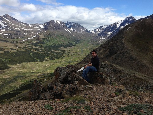
As you climb a mountain like this, you take lots of pictures behind you, as you rise above Anchorage. But as soon as you get to the top, all you do it take pictures of the mountains in front of you. My first thought upon reaching the top was that it looked like mountains from the Lord of the Rings movies. Those mountains of New Zealand are much higher, but I expected to see a small band of travelers crossing the mountain peaks in the distance.
Hiking down the mountain I spotted a moose down in the valley below. That’s two days in Alaska and two moose.
That night I went to the Summer Solstice Film Festival to see some independent films created by Alaska filmmakers at the Beartooth Theatrepub. It’s great to eat real food while watching a movie. I had a blackened salmon burrito and another IPA. The movies were pretty good. It was definitely an in-crowd who knew the filmmakers and the actors. Here’s a review of several of the movies. And when the festival was over, around midnight, I emerged into what looked like dusk.
Day 3
This was the day that I left Anchorage and headed to the interior. I picked up my rental vehicle, a small SUV, and headed north to Talkeetna for my flightseeing tour. I arrived at the airfield early, so I headed into town for a bite to eat at the Talkeetna Roadhouse. I got biscuits and gravy with reindeer sausage. I ordered the small portion and was it filling. I had a long day ahead of me, so filling was good.
After breakfast I followed a wooded trail down to the Talkeetna River. As the trees opened up, I stood on the banks of the river and marveled. The view was incredible. It was expansive. The river was wide and shallow. The land on the other side was flat, and went on for miles. And off in the distance were mountains. Over the course of the trip I got use to always seeing mountains in the distance. No matter what city I visited, and how flat it was, there were always mountains on the horizon. Or closer. Crossing the river was a railroad bridge. I would also see that bridge later from the air.
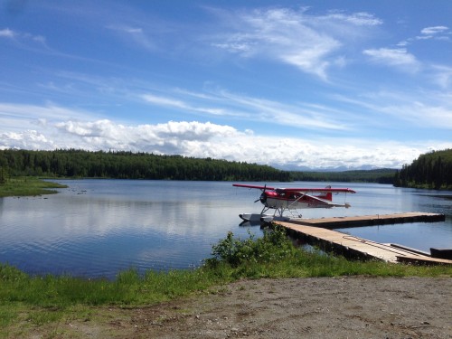
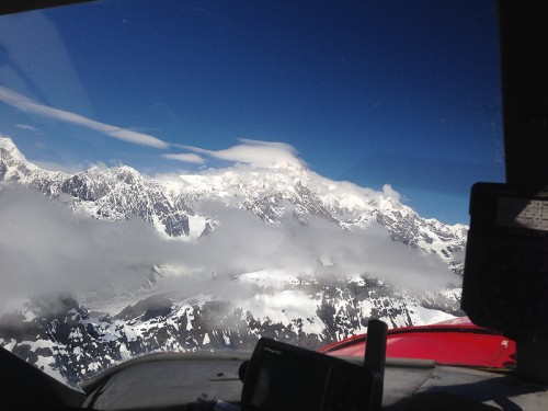
My floatplane took off from Fish Lake. It was beautiful setting. I felt like I was visiting postcard land. Every time I encountered something new, it looked like a postcard. The pilot told me to sit in the co-pilot’s seat. I didn’t have access to any of the controls, but I had the best seat in the plane as we flew towards Denali National Park and Mt McKinley. We were flying over lush, green flatlands with rivers snaking through them as the mountains got bigger in the windshield. As we got closer we saw Mt McKinley with a wisp of a cloud covering the summit. We crossed the Ruth Glacier, flew through a gorge and landed on Backside Lake. It a super smooth landing. Better than most commercial planes. And we landed on water.
Our small tour group was meet by our guides, who camped out on this lake for 7-10 days at a time to guide hikers on a short hike over the local terrain. Most of the flightseeing tours land on a glacier and you get about 15 minutes to walk around, and you get back in the plane. That’s not hiking. And not how I like to travel. That’s more for the cruise passengers, many of whom are older. I choose my excursion because we got to spend several hours in this pristine wilderness. Since the tour company running this trip is the only one that is allowed to land on this lake, I was one of only a few hundred people who had ever been to that spot. This was one reason that we could fill our water bottles from the streams coming down from the top of the mountain. The other was that there was no wildlife back there, so there was no fear of bacteria in the water.
Our guides were a geologist and a college student. They were there to lead our hike, take our pictures, keep us safe, tell us about local mountain formation and nearby glaciers, and serve us wine and cheese after our hike. This was a casual hike on rocky terrain. We were at the base of mountains, not going into the mountains. The plane ride provided the view of the mountains, the hike provided some “feet on the ground” time and the lake and the mountains provided the amazing setting for the afternoon.

The flight back was uneventful, as you hope all floatplane flights over interior Alaska are. The temperature had climbed over 70 degrees outside. This aided our wildlife spotting, as moose were cooling off in the lakes. This was my third moose siting in three days. And from an airplane.
And now it was time to drive back north to Denali. I needed to drive back towards that mountains that I had just been to by airplane on my flightseeing tour. As I left town the view of Mt McKinley was spectacular. All 20,237 feet of it. Not only was that wisp of a cloud covering the summit gone, but all the clouds were gone. I stopped at the rest stop on the edge of town to take pictures. I also took pictures of several families with their point and shoot cameras and their smartphones. I posed families. Asked one girl to move forward to get out of her dad’s shadow. I even explained how it was hard to capture people in the foreground and the mountain in the background. I encouraged people to take mental pictures and remember what it looked like. That would be a better image. And it would last forever.
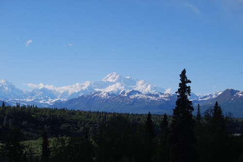
They say only 30% of Alaska visitors ever get a clear view of the mountain formerly known as Denali. And the view I got was incredible. And continuous as I drove north. The picture above is from the southern lookout view at the edge of Denali Park. It was the last great picture spot from the road.
My next stop was Healy, just outside of the Denali Park. It was about a 3 hour drive, plus picture stops and constructions stops. Road construction works differently in Alaska than anywhere else. When many of the original highways were built, it damaged (caused to melt) the permafrost underneath. That’s the part of the ground that is always frozen. If it melts, the roadway is no longer secure and it starts to buckle. The only way to fix it is to remove the asphalt completely and start over. They do this on big sections of the road at once. Both sides. For miles. And this can only be done in the summer. This means that the main highway along one of the biggest tourist stops in the state is a two-lane dirt road in the busiest season. And frequently they only let one lane of traffic through while they’re working. That added time to the drive.
I eventually arrived at my hotel, the Denali Park Hotel. It was a small family-owned hotel, but in addition to the traditional rooms, you could also stay in one of two railroad cars. The office was also a railroad car. This added some charm to place. When I checked in I had a message to call the tour outfitters for tomorrow’s activity: kayaking. It turns out they did not have anyone else signed up for that trip, would I be okay going on the whitewater rafting trip. I said that was fine.
I dropped my stuff in my room and went to get something to eat. It was after 9:00pm and the sun was still shining brightly. It seemed like the middle of the afternoon. I went to the Black Diamond Grill just down the road and had a bison steak. It was a nice break from all the salmon I was eating and it was local. It was the night’s special and was paired with scallops, which I missed in the description. It was good to have a salad and vegetable with my meal. And an Alaskan Amber.
When I went to sleep at around midnight, the sun had not set. The room darkening blinds did a pretty good job of keeping the light out. I happened to wake up at 4:00am and looked out the window. It was just as bright as it had been at midnight. So in the past four hours the sun had gone down and come back up. It was full light again. This was one day away from the longest day of the year.
Day 4
Today was Summer Solstice and in addition to being the longest day of the year, it would be a long day for me. I needed a good breakfast so I went to Rose’s Cafe. I ordered the Grizzly Burger. Between the time I ordered it and when it arrived, I determined that the name described the size, not the meat in this one-pound beef burger topped with ham, cheese and a fried egg. They took my picture for the virtual wall of fame, but I haven’t seen it yet. And yes, I ate the entire burger.
While waiting for my food, I overheard a man talking on the phone to his son and describing Alaska. He was an older guy, and a small businessman. He was in Alaska to buy scrap metal. Not the typical guy who is inspired by the landscape enough to wax poetic about it. That’s just what Alaska does to you. He said the beauty is just so devastating. He actually used the word devastating. And the scenery does not just go on for miles, he said. It goes on for hundreds of miles.
I arrived at the Denali Outdoor Center for my boating tour and geared up in a dry suit. Since we would be rafting on a 36 degree, glacier-fed river, we needed suits that sealed at the neck, wrists and ankles to keep the water out. Everyone going on this trip boarded a bus and drove about 20 minutes to where the rafts put in at the Nenanna River. There were enough people signed up to fill two rafts. One raft had 8 military guys and a guide. Our rafts had five of us and our guide. We got some safety tips and paddling tips on the beach before climbing into the rafts. This is not meant to scare anyone, our guide told us. But you need to know how to stay safe if you come out of the boat.
One of the guys in our boat had GoPro video camera strapped to his chest. I made him sit in the front of the boat. If you are going to video whitewater rafting, you want to see the water, not the back of someone’s head. So this meant our guide directed the boat into every wave so this guy could get good video. Isn’t that what you’re paying me for, he asked.
After we pushed off, we had no contact with the other boat. We practiced paddling as a group and following the commands of the guide. This is definitely easier in calm water. Our trip would go 11 miles down the river and go through about 10 Class II/III rapids. None of them were very long, but some were pretty intense. Starting out, I was a little nervous. I really didn’t want to get thrown from the boat. As we went through the first rapid my nervousness dissipated and it became fun.
One of the best parts of the trip was being at water level. The only way to experience a river is to be on it. Your perspective of a canyon changes when you are down in it, looking up at the mountains. And the only way to understand the current is to paddle your way through the rapids. The guide calls out commands and sometimes your paddle doesn’t even reach the water. There was one time where it beyond exhilarating. We dropped into a trough and hit the wall of a wave. We felt the impact. The boat was at about 45 degrees. We made it through intact, but afterwards one of the other passenger told the guide he thought the boat would capsize. I didn’t think we’d flip, he said. But I was pretty sure someone was going to leave the boat.
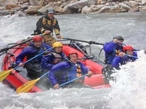
We reached a point in the river called the bathtub and our guide asked if anyone wanted to go in the water. Only one person did. It wasn’t me. We looked towards the other boat and all the military guys were in the water. Some people want to say they swam in 36 degree water. I am not one of those people.
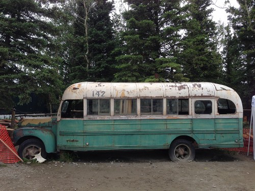
Before I left town on my way to Fairbanks I stopped at the 49th State Brewery to take a picture. Everyone who comes to Alaska these days knows the book and movie, Into the Wild, and the story of Chris McCandless. He died of starvation in a bus out in the wilderness. It is a constant topic of conversation among travelers. The bus was a shelter that backcountry hikers and hunters use. That bus is still there and it is quite arduous to hike out there. But if you are just looking for a picture, the owners of the brewery have the bus used for the movie parked out front. It’s a much safer place to take a picture if you are okay not hiking out into the wilderness.
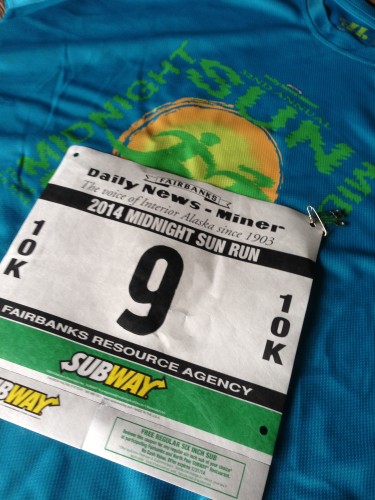
It was only about 2 hours to Fairbanks and it was the first time I encountered any rain on the trip. And I saw a moose along the way. I was now four for four on days and moose, but this would be the last. I got to Fairbanks and had many hours before my race that night. I was running the Midnight Sun Run 10K at 10:00 at night on the Summer Solstice. By the time I got there the rain had cleared. I picked up my race packet at the University of Alaska – Fairbanks and spent some time driving around the campus. I also drove around town and not finding much to see.
I took a shuttle bus to get to the start of the 10K and got there very early. There was a costume contest at 9pm, an hour before the race started. People were dressed as Disney characters, Game of Thrones characters, zombies and one pair was dressed as a mosquito and a can of Off, which squirt out the top.
Clouds started moving in before the start, and it looked like it was going to rain. But the storms never came. It did drizzle during the course of the race, but nothing too bad. This race is the big party in Fairbanks on the Summer Solstice. Since the race runs through many local neighborhoods, people line the streets with camp chairs, portable shelters, outdoor fireplaces and cheer on the runners. I lost track of how many kids I hi-fived as I ran by. Many of the spectators have hoses and water guns to cool off the runners. I accepted all spray willingly.
My time was a little slow, but that’s okay. My official time was 1:04:34 and I was 1,050th out of 3,250 finishers. Definitely was not feeling it for this race, but it was a fun experience. I drank a lot of water, went back to my hotel room and went to bed. Even though it was cloudy, it was still pretty light out. My hotel room didn’t have blackout drapes, so I had to hang the bedspread over the bar to make the room dark for sleep. I had the longest drive of the trip ahead of me in the morning.
Day 5
I awoke to a beautiful sunny day in Fairbanks. I was getting ready to spend the day in the car, so even though I would stop often to take pictures, there was not much activity. Many of my thoughts during this drive were recorded during the drive using my phone’s speech to text feature. These two things combine to make this next section more thoughtful, as well as being in the moment while I was experiencing this landscape. I usually listen to music or podcasts while driving, but I experienced this drive in silence.
It was very early when I hit the road. Minutes after leaving the city I was completely enshrouded in fog. The whole world was shrouded in a very thick fog and I couldn’t see anything. And I had a full day’s drive ahead of me. And just like that the fog lifted in the town of North Pole, Alaska. A town with candy cane light poles and a Catholic Church called St. Nicholas. I didn’t look for the toy workshop, but I’m sure it was there somewhere.

I was on a road called the Richardson Highway, that runs 360 miles from Fairbanks to Valdez. I was not taking it all the way to Valdez, but turning off and heading into the Wrangall-St. Elias National Park. It is the nation’s largest National Park at 13.2 million acres. That’s bigger than Switzerland. It also contains one of the tallest mountains in North America, Mount St Elias at 18,008 feet. America is not a nation of second places. I had never heard of this mountain before, which is only 2,000 feet shorter than Mt McKinley. That’s not why I was headed into this wilderness. Within the park is an abandoned copper mine town. That was my destination.
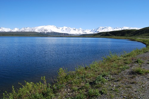
Have you ever been somewhere whose beauty is so awe-inspiring that you just don’t know what to do. This drive was like that. You can’t find the words. You can’t take enough pictures. Because nothing can capture what you’re seeing. Over the course of my trip I took pictures with my digital SLR, my iphone and my Holga with black and white film. The landscapes were so expansive that I couldn’t capture the sense of scale. Don’t get me wrong. I took lots of great pictures. But they really didn’t show what I was seeing. Wide angle didn’t cut it. Panorama on my phone didn’t cut it. I really had to rely on my mental pictures to capture these startling vistas.
I’m not used to being at a loss for words but I just couldn’t find the words to continue to describe what I was seeing. Essentially, I ran out of superlatives. I would see something in front of me that was one of the most beautiful views I had even seen and I would almost get complacent with the view. And then I would go around a bend and see an even more beautiful view. It was the most awe-inspiring landscape I have ever seen. I like visiting cities and taking in the architecture, but the expansive views in Alaska were just incomparable. Even in the rear view mirror.
I reached the town of Chitina and entered the National Park. This last part of my trip was on a 60-mile dirt road. Those words never really sunk in. Say them with me. 60-mile dirt road. With a maximum speed of 30mph, that’s two hours driving on a dirt road. This was the old railroad bed that led to the copper mine town. At the end of this dirt road was a parking lot where I would leave my car during my stay here. The only access to McCarthy and Kennicott, the two towns that supported the mine, was by footbridge.

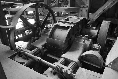
After a shuttle ride and checking into my room at the Kennicott Glacier Lodge, a re-built replica of housing from the boom town days, I wandered around town before dinner. There was a mix of renovated buildings and un-renovated buildings. The centerpiece of the town is the 14-story mill building. It has not been renovated, but I found out later that the building had been secured enough for inside tours. I had already signed up for this tours months before, never expecting to go inside this building.
Dinner at the lodge was family-style. One seating at 7pm. I was concerned that I would not make it in time, because of the long drive, the dirt road and the footbridge. I was in town by mid-afternoon, so I had no problem making it. There were assigned tables but not assigned seats. I sat down at one end of the table. There was someone else at the other end of the table. I looked at the table assignment and saw that in addition to us, two single travelers, a party of six would be joining us. I suggested to the woman that she should move down across from me so the six people could sit together.
During the course of dinner, Emily, a doctor from Portland, Oregon, and I talked about our plans for the next day. I was planning on taking a glacier hike and she was going ice climbing. I didn’t really know what ice climbing was, beside the obvious, climbing up ice, but I figured why not do that. Both tours were run by the same company, so if there was room, it would be easy for me to change trips. There was room, so I was going ice climbing the next day. And Emily and I became travel buddies for the rest of my Alaska trip.
Since this was a National Park, there were ranger-led tours of the abandoned town of Kennicott. We took that tour after dinner and got a good overview of what went on in the town from 1911 to 1938 when it was an active copper mine. Prospectors discovered the largest vein of copper ore in the world in the mountains above the town. With backing by J.P. Morgan and Guggenheim, a company was started to mine the ore and prepare it for shipping. A 200-mile railroad line was built, a town that housed 600 people grew around the mine, and the mill to process the ore was built. When the copper ran out in 1938, the company shut down the mine, told the workers to go home and just left. In that brief period of mining and processing they made $100 million profit. That’s the equivalent of $3 billion today.
Day 6
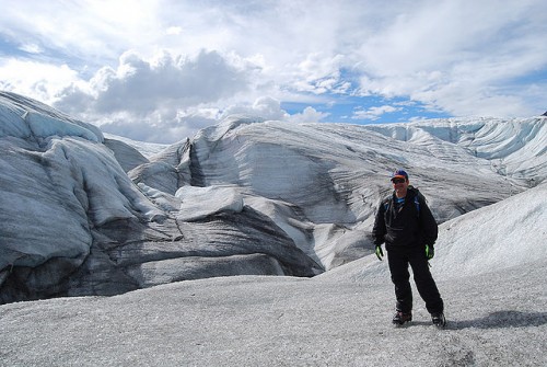
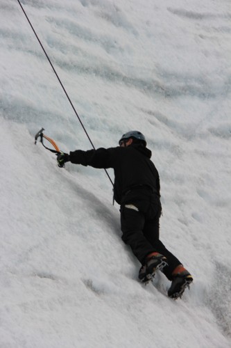
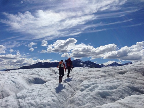
Our ice climbing adventure began by getting outfitted with our gear. The main things we needed were hard plastic boots (similar to ski boots), crampons (spikes that attach to the boots), a harness around our waists to attach the ropes and a helmet. We gathered up our things and headed out on a two-mile hike to the glacier. In addition to Emily and me, Dave, a waiter at a local restaurant in McCarthy, was on our trip. Our guide was a guy who’s name was Brian, but for some unknown reason we called him Brady all day. He never corrected us.

It was a rainy morning and we started off with all of our layers on. As we walked, the rain let up and we started shedding our layers. No matter what you do in Alaska you need to dress in layers. The temperature constantly changes, especially as you are active outside. That morning we were rewarded by a rainbow. A big, spectacular Alaska rainbow.
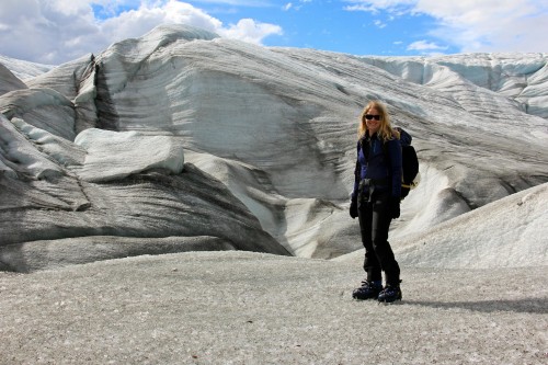
This was the day that I really learned about glaciers. Many people confuse icebergs with glaciers, and I was one of them. An iceberg is like an ice mountain, but a glacier is more like an ice river. The one we were headed for was 7 miles long, a mile wide and 1,000 feet thick of ice. There is also water running across the top of it, down it and hundreds of feet below the surface.
We got to the edge of the glacier, changed our hiking shoes for our boots with the crampons attached and headed out. The glacier ice was different than I expected. It was solid, but granular at the same time. And as the sun warmed it, there were streams, ponds, puddles all around. We reached our destination, an 85-foot ice wall next to a shallow pond. The water in the pond looked very blue, and it was only inches deep.

Brady, since I called him that all day I will call him that here, went to the top of the ice wall and anchored the belay ropes into the ice. We had our training session of what to do. The rope would secure us, so there was no chance of falling. It would also be supporting some of our weight. With an ice tool in each hand and crampons on your boots, you drive all four points into the ice and you remove one at a time move it to a higher level. This is how you work your way up the ice wall.
Dave went first. He made it look pretty easy. But when he came down he shared some lessons. He said the hardest part was the decent because you have to just lay back and trust the rope. Emily went next and then it was my turn. It wasn’t easy, but it wasn’t hard. It’s not about upper body strength because your weight is distributed across your four points, plus the rope. It’s more about coordination and practice. That’s true when the ice wall is vertical. For our next climb, we move over to a spot where there was an overhang. That was very different.
But before that happened I had one of my most surreal moments in Alaska. I needed to pee. The procedure for going to the bathroom on a glacier is you just walk over the next rise, out of the view of your companions, and you go. But this is Alaska and there is so much wide open space around. It feels like you are just standing there, out in the open, going. Because you are.
It was time for our second climb and we went in the same order. Dave first, then Emily, then me. When you start off climbing, you are more or less walking up a slight incline. As the ice wall goes vertical, you drive your four points of contact in and begin navigating your way up. One of the best parts about this small group was that there was no pressure to outdo each other. After my first climb, I admitted that I wanted to rest, but neither Dave nor Emily did, so I couldn’t. Resting involves taking the pressure off your hands and feet and letting the rope support you. On Emily’s second climb she rested so I would not feel uncomfortable doing so. And did I need to rest on this second climb.
About ten feet from the top was the overhang. I felt very unbalanced when I reached it. Not unbalanced like I would fall, but I was leaning back. It made it hard to continue my forward progress. I took a break and let my arms dangle. I didn’t know if I could make it. I re-engaged my four points of contact with the ice and set to try again. I took another break to gather myself. The little kid voice inside me said I can’t make the top. I’m ready to come down. It’s too hard. But the adult voice, the one that should be controlling me, said, yes, you can. Just take it one step at a time. I made small movements each time. Hand, hand, foot, foot. I stopped worrying about my unbalanced feeling and focused on the movements. The same each time. In the same order.
Suddenly I realized I was at the top and seeing over the edge. I felt an amazing sense of accomplishment. I had literally overcome a large obstacle in front of me. I was sweating profusely under my layers. It was a struggle, but it felt great. I also new that this was my last climb today. I wasn’t sure how I would handle something harder, plus I didn’t know how I could top this sense of achievement.

Brady removed the ropes and we headed off across the glacier. We were looking for other things to climb, but it was also fun just tromping along the glacier. There were lots of different glacier features including shallow lakes and streams that we crossed. Brady told us that some of these features change every day. Because it was so warm that day, nearly 70 and sunny, there was a lot of water on the surface of the glacier. All that water has to go somewhere. It flows into holes called moulins. These can drop 150 to 200 feet down into the glacier. You do not want to fall into one of these, because you will not survive the fall. And even if you did, it is too far down to be rescued. Especially with the flowing water. This was to be our last ice climb.
That’s right. Brady would lower us 30-40 feet into the moulin and we would climb out. I was already done and this clinched it. I enjoyed my sense of accomplishment from the last climb. This climb would actually be easier, but I had no interest in getting lowered into a moulin. I completed trusted our guide and our equipment, but I just was not interested. And again, nobody in our group tried to convince me otherwise, either before or after their climbs. As usual, Dave went first and Emily went next. Brady gave Emily an extra harness to make sure she remain straight and secure during her climb. Both of them described it as very loud from all the water running down, but an easy climb back up. Brady removed the ropes, packed everything up and we headed back across the glacier to town.
At dinner that night Emily and I talked about the limited beer selection at the lodge. There are lots of great craft beers in Alaska and the only thing they served besides the usual mainstream swill was Alaska Amber. It’s okay, but not very interesting. We had heard that the bar in McCarthy, The Golden Saloon, had a good beer selection, including one of her favorite IPAs from Portland, Ninkasi. We had our evening adventure. We were going to McCarthy to get a beer.
Normally that would not seem like an adventure, but it was 5 miles away down a dirt road and we didn’t have cars. I left mine on the other side of the foot bridge and Emily made the smarter decision and flew into McCarthy. There are no taxis or shuttles at night so we had to get creative. We asked at the front desk and they found us a ride down there with the lady presenting a slide show that night at the lodge. But we had no idea how we would get back.
So we prepared on the chance that we had to walk back. That meant bringing water, a raincoat, another layer for cold and snacks. After the slide show we caught our ride down to McCarthy. We walked into the bar and it was about what you would expect. A bar with about 10 stools in one room and 8-10 tables in the other. It wasn’t crowded, but there were mainly locals and summer locals in there. Since there was no way to get around at night, there were not any other tourists there.
We drank our beers and talked, not really worrying about how we would get back. I felt confident that we would not be walking back. We could do it if we had no other options, but I didn’t think it would come to that. When the waitress came to check on us, I asked if there was anybody that could take us back up to the Kennicott Lodge. She said that she would see. She also brought the check and told us it was nearly last call. The owner of the bar came over and told us he would get us a ride back. You can’t walk back up there, he said. One of the bartenders drove us back, saving us a five mile walk in the perpetual Alaskan twilight. It turns out when people eat next door in the fine dining restaurant they get a ride back to the lodge.
Day 7

This was my last day in Alaska. I had one final tour in Kennicott, inside the mill itself, and a long drive back to Anchorage. The mill was built to process the copper ore and prepare it for its 200-mile rail journey to the nearest sea port. The ore came by tram from the mines up in the mountains and was dumped into a crusher. The mill was 14-stories tall and the ore went through a series of steps, floor by floor, to extract the copper ore from the limestone using water, gravity and a series of custom machines that were engineering innovations of the time. And like the rest of the abandoned town, when the ore was all extracted and everyone left, this building and all its machines were left in their places. Over the years pieces and parts disappeared, but historians and engineers have figured out how most of it worked.
I don’t know why people come to Wrangell St Elias National Park, or more specifically, Kennicott, because it is pretty out of the way. Even for Alaska. I learned about the copper mine more than 15 years ago working for a model train company. We produced trains decorated for the Kennecott Copper Company and the thing we wrote about in our newsletter was their Alaska mining operation. It was much more interesting than the current global conglomerate that exists today. Our newsletter featured a photo of the mill building high on the hill overlooking the town. As I was researching places to visit and came across this town I knew I had to see it for myself. I had only seen historical black and white photos so I was surprised the buildings were red.
During our stay in Kennicott we had heard that John Denver was a big fan of the area. One of the park rangers had a DVD of John Denver visit the area. He said there was a crazy chase scene through the town of Kennicott. In the late 1970s the singer made a documentary, actually a tv special, where he traveled around Alaska in an airplane. The conservation movement was still a fringe idea and he wanted to convince people that Alaska really was the last frontier and it was worth preserving. We got the ranger to show us part of the DVD before we had to leave town on the shuttle.
The scenery from the air was beautiful. His tour of the town was interesting because this was before any of the renovation was done. It was still privately owned and not part of the national park, and wouldn’t be for another 20 years. While walking around he said it reminded him of the Old West and there should be a chase scene. Suddenly he starts running. The film is sped up and campy chase music starts playing. His guide plays along and begins chasing him. In doors. Out of doors. Up the side of the mill. Up steps. Down steps. In front of buildings and behind buildings. It was just as cheesy as it sounds. And pretty incongruous with the tone of the rest of the show. But it was amusing. And our final takeaway from the town of Kennicott.
Eight people got on the hotel shuttle. Seven of them were going to the airport to fly back to the entrance of the park. I was the only one going to the footbridge with a 60-mile dirt road ahead of me. We dropped them off at the airport and I said goodbye to Emily. It was fun to have a travel buddy. I have done plenty of traveling alone, which I do enjoy, but it was nice to travel with someone for a couple days on this trip. And I already have plans to travel with Emily again.
I was back in the car and on my way. It was cloudy and drizzly for much of the drive, but I still stopped and took some pictures along the way. I saw the Matanuska Glacier, but there really was not a great picture spot. This drive was the least dramatic from a scenery point of view. But it was also the end of a long week and I don’t know how much more of the expansive landscapes I could take. Plus I had a plane to catch.
I drove into Anchorage in the early evening and had plenty of time before my flight. I went to a carwash to wash the 60 miles of dirt road off. You’re not supposed to take rental cars on dirt roads, but in Alaska sometimes you have no choice. I didn’t want anyone asking me about it. Especially since my vehicle was so new it still had temporary tags on it. It had around 500 miles on it at the start of my trip and I drove over 1100 miles.
Dinner in a restaurant would be much better than anything I could get at the airport. Just to make sure I got my final fill of Alaskan salmon, I had jambalaya with salmon and a local IPA. This was a good last meal in Alaska.
If you have made it all the way to the end of this post, thank you. If you have been to Alaska, I hope this brought back fond memories of your trip. If you haven’t, I hope this inspires you to go someday.
I have been changed by Alaska. After seven days of seeing mountains in the distance, I got used to them being there. There are no mountains in Indiana. But I have come to appreciate the wide open spaces, of which there is plenty in Indiana. I’m trying to spend more time outside. And I’m also trying to focus more on the moment and be present where I am. Every second does not have to be filled with screentime. It’s easy to do this outside and enjoy what’s around you, but I also do this now in other places like restaurants. I’m a little more contemplative and less connected. It just feels right after returning from America’s last frontier.
Below is a slideshow of pictures. You can click through them here (make sure you click the full screen button) or you can view them directly on Flickr.